Raster Resolution
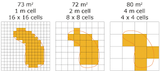
So, basically we are going to discuss about the resolution of the Raster data in GIS. Raster data represents the real world in grid or cell format. So the detailing depends on the cell size(the area covered in the ground by a single cell) . i.e if a entity is represented in the minimum cell size of 1m×1m (which is first one in the image),2m×2m(second one) & 4m×4m(last one).
Raster resolution
So, the best resolution came from the first one then second one and then the last one.
We can say that the samaller cell size for higher resolution and larger cell size higher resolution. If we talk about accuracy then it also depends on the cell size.So we have to choose the raster as small as possible to get the higher accuracy in GIS.


Comments
Post a Comment